The History Of Antarctica In Maps - Nexta Expeditions
The History of Antarctica in Maps

The History of Antarctica in Maps

Long before human eyes ever beheld Antarctica, the ancients were convinced that it existed – or at least something like it.

Ptolemy, a Greco-Roman astronomer who lived from roughly 100 to 170 CE, thought that an enormous far-southern landmass had to exist to provide a planetary counterweight to the large continents of the north. This hypothetical region, which had never been seen much less mapped, even had names: The term “Antarctic,” coined by Greek geographer Marinus of Tyre back in the 2nd century, referred to an imagined area opposite the Arctic Circle; and in the 5th century, the Roman scholar Macrobius included a southern territory called Australis (Latin for “of the south”) on his maps.

Later medieval references to Terra Australis Incognita, or “Unknown Land of the South,” would elaborate on these old-fangled theories, and maps drawn between the 15th and 18th centuries often included it at the bottom. None of these names or renderings truly referred to the Antarctica we know today, since it would be hundreds of years before the continent was actually seen, but they did fuel a geographical myth that persisted for centuries.

A number of later voyages through the late 1700s charted many of the waters into which Terra Australis was thought to extend, and either reduced or eliminated it from maps altogether. It was not until 1820 that a confirmed sighting of Antarctica did occur. Even so, the centuries-long cartographical transformation of Terra Australis into Antarctica is a fascinating record of the evolution of modern geography.

Below is a list of maps that, while by no means complete, follows this evolution in some of its key phases. More than mere directional aids, these maps are beautiful fusions of art and science crafted centuries before the benefit of modern navigational equipment.
blog-image

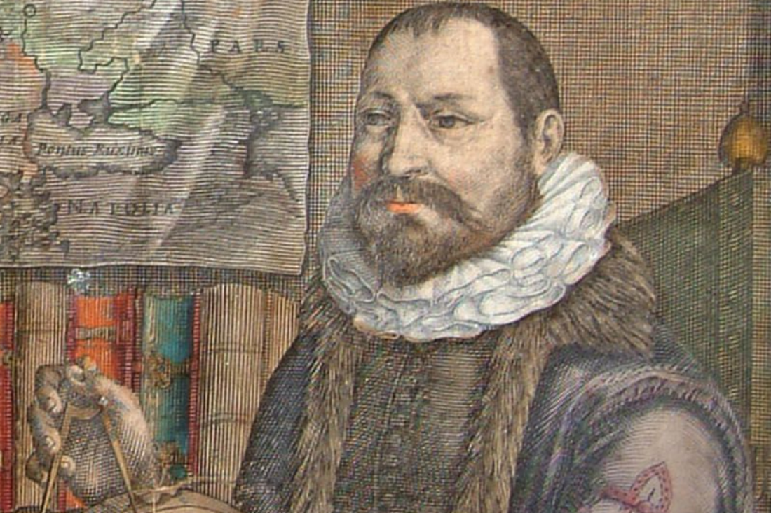
1570: Abraham Ortelius and the Theater of the World

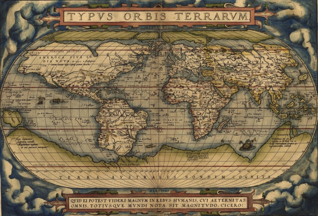
One of the most famous maps on which Terra Australis first appears forms a central segment of the world’s first modern atlas. Flemish cartographer Abraham Ortelius’s renowned Theatrum Orbis Terrarum, or “Theater of the World,” is a compendium of all the latest maps drawn by his contemporaries, representing the sum of 16th century cartographical knowledge.

Ortelius is among the most famed mapmakers of the Dutch golden age of cartography, which occurred between the 16th and 17th centuries. Among the chief sections of his atlas is the Typus Orbis Terrarum, a world map that depicts Terra Australis as being by far the largest landmass in the known world: It fills most of the space south of the Tropic of Capricorn, nearly touching the southern tip of South America, and extends all the way to New Guinea. Ortelius’s atlas, a pivotal development of world geography, was a mainstay of navigation and was regularly updated over the ensuing decades.
blog-image

1590: Petrus Plancius and the Orbis Terrarum

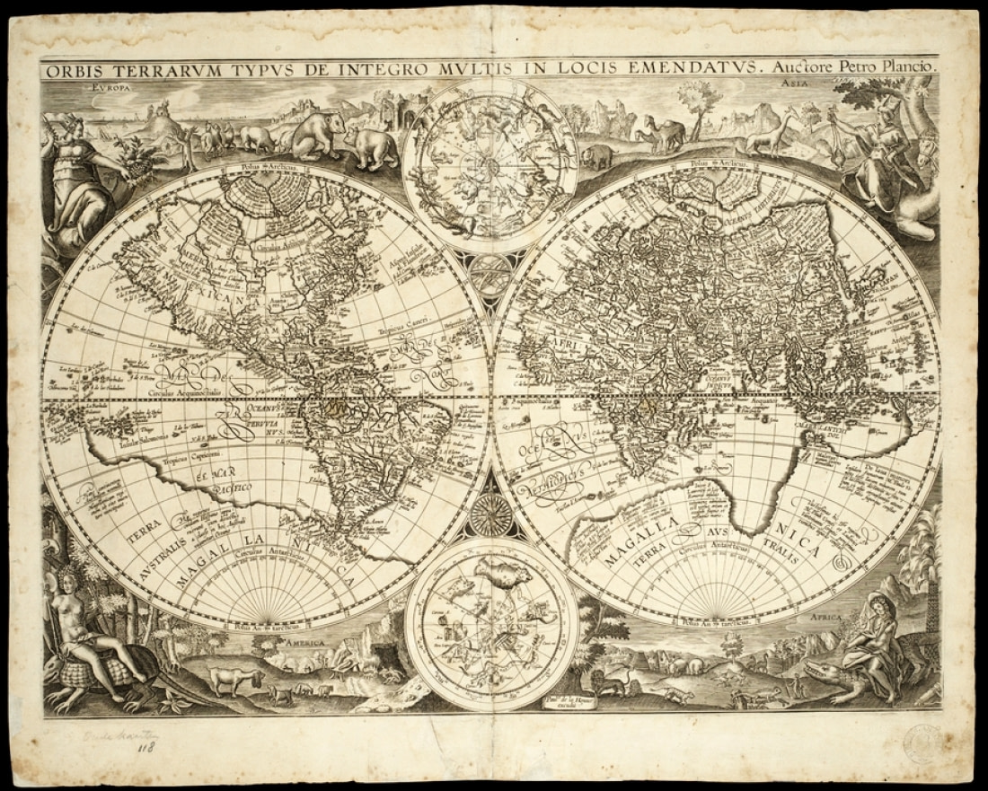
Known more for its coverage of the Arctic and Far East than for its depiction of the far southern landmasses, Dutch-Flemish cartographer Petrus Plancius’s Orbis Terrarum represents Terra Australis in much the same way Ortelius’s Theatrum did twenty years earlier.

Originally completed in 1590, Plancius’s world map depicts Antarctica as nearly reaching the southern end of South America, like Theatrum. It also shows the continent extending north almost to New Guinea and Java, like Ortelius’s map, reaching far into the Indian Ocean and terminating relatively close to the southern shores of Africa.

Plancius was not known only for cartography, however. He wrote navigational guides, innovated a new system for determining longitude, and collaborated with Dutch mapmaker Jacob Floris van Langren on a celestial globe that depicted several southern constellations not previously illustrated in maps.
blog-image

1630: Henricus Hondius II and the Nova Totius

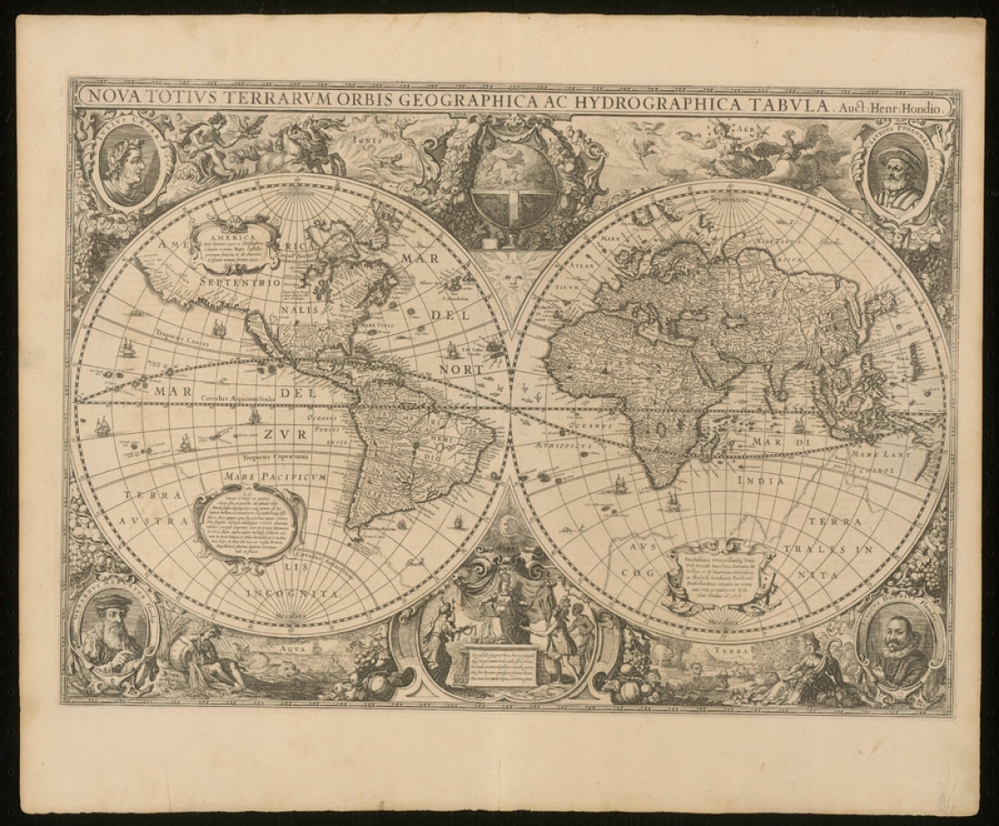
Forty years after Plancius made his mark on the cartographical world, Henricus Hondius II finished his own world map, the Nova Totius Terrarum Orbis Geographica ac Hydrographica Tabula. As if that weren’t enough of a mind-boggling mouthful, there happened to be two Henricus Hondiuses practicing cartography in the Dutch Republic at the same time. Though they were contemporaries, they were not related, and in fact Hondius I was Flemish born despite later settling in Amsterdam – where, incidentally, Hondius II was born.

Like Plancius, Hondius II worked with materials originally produced by an earlier cartographer, Gerardus Mercator. Mercator, one of the few major cartographers who for reasons of concision is not represented in this list, created his own world map in 1569 that shows Terra Australis in much the same way Ortelius would in his 1570 atlas and Plancius would in his 1590 world map.
blog-image

1741: Covens & Mortier and the vanishing Australis

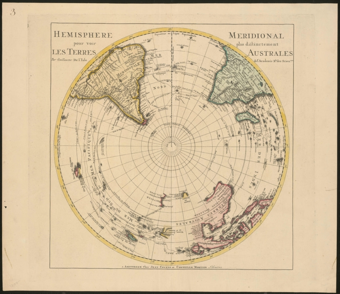
By the 18th century, the Dutch cartographical golden age had produced a number of enormous (and enormously successful) map publishers. One of the largest was Covens & Mortier, founded in Amsterdam by Johannes Covens and Cornelius Mortier.

Among their long tradition of impeccably drawn maps was a rendering of the Southern Hemisphere that does not depict Terra Australis at all. This was a common result of further exploration into the southern seas: As navigators began to learn how far the seas extended to the south, the available room for the once-colossal Terra Australis naturally diminished.

In fact, explorations undertaken in the previous century had already disproved much of the hypothetical southern continent’s dimensions. Tierra del Fuego, for example, was revealed as being smaller than originally thought, and Australia was found to not be part of a larger continent. In 1770, James Cook continued this reduction by showing that New Zealand was not part of Terra Australis, which he deduced must be located within the polar region of the Southern Hemisphere.
blog-image

1749: Du Vaugondy and the Mappe-Monde

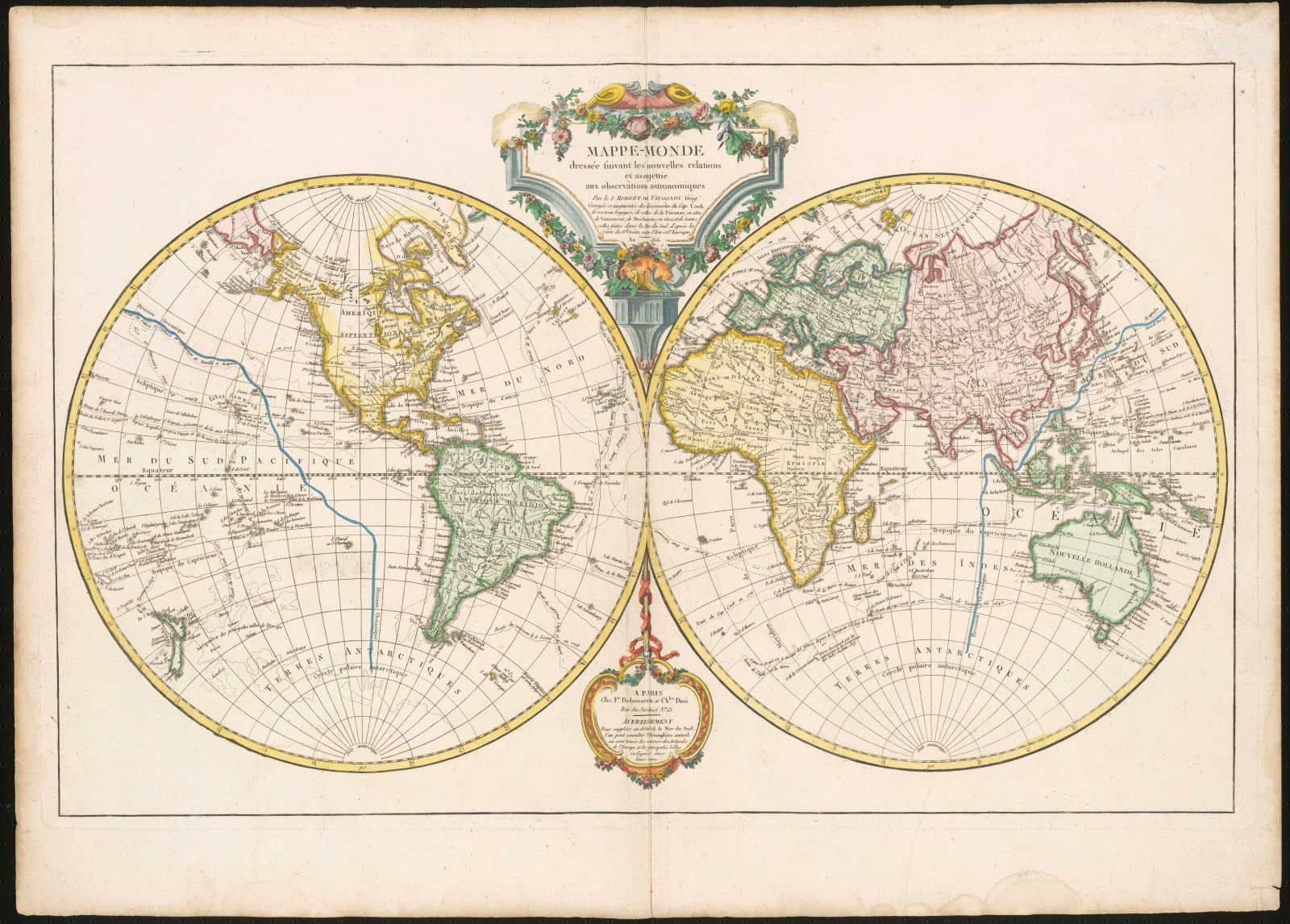
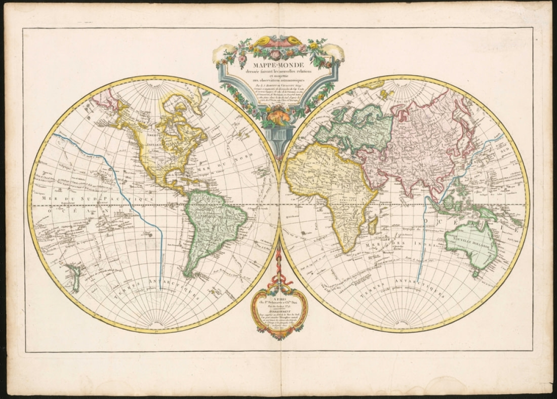
Gilles and his son, Didier, two of the 18th century’s most well-known French cartographers, produced some of the last maps to predate the confirmed 1820 sighting of Antarctica. One of their most extensive maps, the 1749 Mappe-Monde, also omits Terra Australis. The landmass is replaced with the unknown area of Terres Antarctiques, translating simply to “Antarctic Lands.” The version of the Vaugondy map shown in this image was released in 1816 and includes updates resulting from the discoveries of multiple explorers after the original 1749 release.

Other parts of the world are nearly as blank as the Antarctic region, such as America’s Pacific Northwest. It would be some time before this area would be filled in, much like Antarctica, but if nothing else these blank portions suggest that cartography was moving away from its reliance upon ancient conjecture. The system and science of map making, advancing all the more rapidly with the innovations spurred by the Age of Discovery, would in turn progress map by map toward the state we find it in today.
blog-image

Blog
go-leftgo-right

Humpback Whales: the Stars of the Western Antarctic Peninsula - Nexta Expeditions
Blog

Humpback Whales: the Stars of the Western Antarctic Peninsula

The marine ecosystem of the West Antarctic Peninsula (WAP) stretches from the Bellingshausen Sea to the northern tip of the peninsula. This region includes the Antarctic Sea Ice Zone, a highly productive area that supports large populations of marine mammals, birds, and Antarctic krill. One of the highlights of this region, which you can observe on a whale-spotting Antarctica cruise, is the humpback whale.
The Norse Settlement of Greenland - Nexta Expeditions
Blog

The Norse Settlement of Greenland

Erik the Red is a significant and vibrant figure in the history of the Norse Vikings. His story is primarily documented in the Icelandic Sagas Huaksbók (14th Century) and Skalhóltsbók (15th Century). These accounts offer slightly different versions of events that occurred 3-400 years earlier. The original saga of Erik the Red is believed to have been written around 1200 A.D., with the Skalhóltsbók version considered closest to the original. Additionally, Flateyjarbók (13th Century), which includes the Saga of the Greenlanders, is a crucial source for understanding the settlement of Greenland and the discovery of Vinland – North America.
10 Tips for Photographing the Northern Lights - Nexta Expeditions
Blog

10 Tips for Photographing the Northern Lights

The northern lights, also known as the aurora borealis, offer some of the most breathtaking photographic opportunities in the Arctic. However, capturing this stunning phenomenon requires more than just luck. To take your best northern lights photos, it's helpful to understand some key aspects of aurora-specific photography.
Arctic on Foot: Hiking and Snowshoeing the Far North - Nexta Expeditions
Blog

Arctic on Foot: Hiking and Snowshoeing the Far North

The focus of our voyages is always to get you off the ship and into the action as frequently as possible. While we travel from site to site on ice-strengthened vessels, our expeditions are crafted to provide you with the maximum firsthand experience of the polar regions and their unique wildlife.
How Arctic Wildlife Differs from Antarctic - Nexta Expeditions
Blog

How Arctic Wildlife Differs from Antarctic

While the north and south poles share certain characteristics, they are also remarkably distinct. Both regions are cold and dry, yet each has its own unique terrain and climate. The Antarctic is particularly harsh and inhospitable, with only two native vascular plant species, whereas the Arctic tundra supports a wider range of fauna due to its relatively warmer temperatures and greater plant diversity. Here are some of the animals you can find in the Arctic compared to the Antarctic.
Of Treacherous Rocks & Audacious Fin Whales - Nexta Expeditions
Blog

Of Treacherous Rocks & Audacious Fin Whales

Soon large blows filled our view; small groups of fin whales sped by heading north all the while feeding on concentrations of krill & small fish. Group after group was seen, with many simply feeding in the general area and not heading anywhere in particular. Soon it became evident that we were not simply seeing a few random groups of fins, but a very large concentration spread out over a large area of sea just north and around the islands north of the South Shetlands. Dozens upon dozens of fin whales were feeding, diving around the ship and on the horizon in massive numbers; we must have seen well over fifty fin whales in the general area of Elephant Island, something many of the guides had never seen before.
9 Facts about the Greenland Shark - Nexta Expeditions
Blog

9 Facts about the Greenland Shark

The Greenland shark, or Somniosus microcephalus, is one of many fish that inhabit the waters around Greenland, though this is not the only area in which the shark resides. These sharks, sometimes referred to as “gray sharks” or “gurry sharks,” can also be found in the north Atlantic Ocean near Iceland, Norway, and Canada.
The Arctic Hare: Easter Bunny - Nexta Expeditions
Blog

The Arctic Hare: Easter Bunny

Although the Arctic hare’s stern expression might make it seem like the least amused member of a serious tribunal, this polar animal is actually one of the most charming creatures on the planet – especially when Easter Sunday comes around.
Going Green: Ascension Island Sea Turtles - Nexta Expeditions
Blog

Going Green: Ascension Island Sea Turtles

Gold beaches, green mountains - and greener turtles.
Weddell Sea: the Original Antarctic Adventure - Nexta Expeditions
Blog

Weddell Sea: the Original Antarctic Adventure

According to historian Thomas R. Henry, visiting the Weddell Sea requires a brave heart. In his 1950 book, "The White Continent," he described sudden “flash freezes” that occur in the region. It was one of these flash freezes that trapped Ernest Shackleton’s ship, Endurance, in January 1915, forcing his crew to endure over a year in the harsh environment before they could escape.
Antarctica Cities (and Five Other Things That Don’t Exist There) - Nexta Expeditions
Blog

Antarctica Cities (and Five Other Things That Don’t Exist There)

Why write about what you won't find in Antarctica? Most travel blogs highlight what a destination offers, but many polar tourists visit Antarctica to experience a new world and escape their old one.
Graham Land: A landscape dominated by volcanoes - Nexta Expeditions
Blog

Graham Land: A landscape dominated by volcanoes

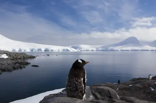
An Antarctic cruise may explore the upper tip of the Antarctic Peninsula where one finds Graham Land, a jagged, glaciated part of Antarctica with a landscape dominated by volcanoes. Despite the volcanoes being over 200 million years old they are far from extinct with volcanic activity occurring today. Graham Land is connected to Palmer Land at the point where the Antarctic Peninsula widens from around 75 km to around 200 km south of Marguerite Bay.
South Georgia in Spring - Nexta Expeditions
Blog

South Georgia in Spring

What a fantastic time to be in South Georgia! Perhaps the best time of the year! The wildlife is abundant, and the light is simply magical for photography. Kings, Gentoos, Chinstraps, and Macaronis are all present along the shorelines. Elephant and Fur seals are also plentiful! Wandering albatrosses are welcoming their newly hatched chicks, while the non-breeders are actively engaged in their courtship rituals, practicing a ceremonial dance. Light-mantled, Sooty, and Grey-headed albatrosses are still feeding their fluffy chicks, as are the Giant petrels. We've been fortunate with the weather, finding ourselves in the right place at the right time to succeed in all our landings and zodiac cruises so far.
Imperial Antarctica: the Snow Hill Emperor Penguins - Nexta Expeditions
Blog

Imperial Antarctica: the Snow Hill Emperor Penguins

Recently, a rare achievement was made by visiting Antarctica’s northernmost emperor penguin colony on Snow Hill Island. Typically surrounded by impassable pack ice, Snow Hill is a notoriously difficult destination in the Weddell Sea cruise itinerary, only accessible using helicopters carried especially for this purpose.
Antarctica: When to Visit, How to Plan, What to Expect - Nexta Expeditions
Blog

Antarctica: When to Visit, How to Plan, What to Expect

Antarctica is an astonishing location loved in equal measure by ice enthusiasts and continent hoppers, but it also asks a lot in return for its prestigious polar status.
Svalbard a Disneyland for geologists - Nexta Expeditions
Blog

Svalbard a Disneyland for geologists

Svalbard is situated in the north-western corner of the Eurasian plate. Historically, Svalbard was part of a vast continent that included North America, Greenland, and Eurasia. At one point, both Northeast Greenland and Svalbard were submerged under the ocean before resurfacing.
Arctic Foxes: Constant Gardeners of the Arctic - Nexta Expeditions
Blog

Arctic Foxes: Constant Gardeners of the Arctic

Given how widespread their habitat is, it is little wonder that Arctic foxes are one of the animals we most often see during our Greenland and Svalbard expeditions. The Arctic fox is a circumpolar species whose feeding grounds include North America, Eurasia, even Iceland, ranging from nearly the North Pole all the way down to the sub-Arctic islands.
Adélie Penguins: the Little People of the Antarctic - Nexta Expeditions
Blog

Adélie Penguins: the Little People of the Antarctic

Described as “an object of endless pleasure and amusement” by Apsley Cherry-Garrard, survivor of Robert Falcon Scott’s ill-fated Terra Nova expedition to the South Pole, the Adélie penguin stands with the regal and iconic emperor penguin as one of only two penguin species found on mainland Antarctica.
The ozone layer in Antarctica - Nexta Expeditions
Blog

The ozone layer in Antarctica

An ozone molecule is composed of three oxygen atoms rather than the usual two. It exists in the atmosphere in trace amounts. Ozone molecules are created through the interaction of ultraviolet (UV) radiation from the sun with oxygen molecules: When an O2 molecule is split, the two free oxygen atoms bond with other O2 molecules to form O3 molecules.
Why You Should Visit Greenland: 11 Things to See, Do, and Explore - Nexta Expeditions
Blog

Why You Should Visit Greenland: 11 Things to See, Do, and Explore

There's nothing quite like witnessing your first Greenland glacier, navigating into the island's largest fjord system (which also happens to be Earth's largest), or observing a humpback whale breach over the dark Greenland Sea.